Venus has often been called Earth’s sister planet, mainly because the two are roughly the same size. And there the similarity ends. One significant difference is that Venus is covered by an opaque cloud layer that does not allow direct visualization of its surface. For this reason, early probes making flybys of Venus didn’t even carry cameras. In 1961, using Earth-based radar scientists were for the first time able to peer through the clouds and obtain very low resolution “images” of the surface of Venus. By the mid-1970s technology had improved so that Earth-based radars could provide surface resolution down to about 10 kilometers, but only of limited areas of the planet. The next step was to place a small radar instrument into orbit around Venus – what it lacked in size it more than made up for in proximity to the surface.
The first spacecraft to study Venus using radar was Pioneer Venus Orbiter, managed by the NASA Ames Research Center in California’s Silicon Valley, which entered a polar orbit around the planet in December 1978. Over the next 14 years, among other observations it mapped approximately 90% of Venus at a resolution of about 10 kilometers. Pioneer Venus found the planet to be almost perfectly spherical, unlike Earth which has a measurable bulge at the equator. Also, more than half of Venus’ surface is within 500 meters of the mean surface height. The radar imagery found two large continents, Ishtar Terra roughly the size of the United States and Aphrodite Terra about the size of Africa, as well as large-scale tectonic features such as rift valleys and volcanic calderas.
As good as the results returned by Pioneer Venus Orbiter were, scientists yearned for higher resolution radar imagery. The Soviet Union obliged by launching two spacecraft carrying Synthetic Aperture Radar (SAR) instruments with large antennas. Venera 15 and 16 entered polar orbits around Venus in October 1983 and during their eight-month missions mapped about a quarter of the planet’s surface to a resolution of 1 to 2 kilometers. During this time, NASA was planning its own mission called the Venus Radar Mapper, later renamed Magellan, with the capability to map the planet down to a resolution of 120 meters using SAR. Magellan’s prelaunch goal was to map up to 70% of the planet during one 243-day imaging period, equivalent to one Venusian “day.” The Jet Propulsion Laboratory in Pasadena, California, managed the mission.
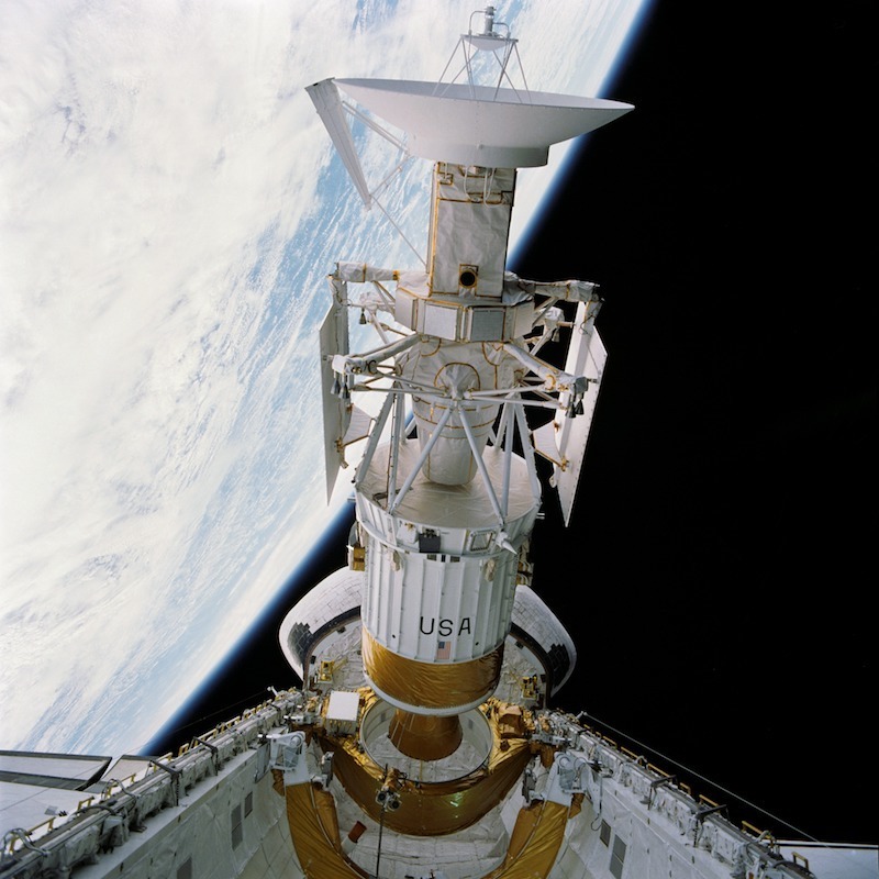
Magellan became the first planetary probe to be launched by the Space Shuttle when it blasted off from the Kennedy Space Center inside Atlantis’ cargo bay on May 4, 1989, during the STS-30 mission. The crew of David M. Walker, Ronald J. Grabe, Mark C. Lee, Norman E. Thagard, and Mary L. Cleave deployed the 7,604-pound Magellan and its Inertial Upper Stage (IUS) the next day. One hour later, the IUS ignited to send Magellan on its 15-month journey to Venus. After several mid-course corrections, Magellan settled into a near-polar orbit around Venus on Aug. 10, 1990.
On Sep. 15, Magellan began returning high-resolution radar images of Venus’ surface, showing evidence of volcanism, tectonic movement, lava channels and pancake-shaped domes. During the 243-day mapping cycle that ended May 15, 1991, Magellan mapped 83.7% of the planet’s surface with unprecedented resolution, exceeding its pre-mission objective. The spacecraft remained healthy and NASA extended its mission to conduct an additional five 243-day imaging cycles, which in aggregate increased the area of the planet mapped to 98%. In addition to radar imaging, Magellan also made precise measurements of Venus’ gravity field and used the planet’s atmosphere to circularize its orbit in the first test of the aerobraking technique. During its final cycle, Magellan studied Venus’ upper atmosphere. On Oct. 13, 1994, after a series of controlled engine firings lowered its orbit, Magellan entered Venus’ atmosphere and burned up, having completed its highly successful mission during more than 15,000 orbits of the cloud-shrouded planet.
Magellan’s high-resolution radar global map of Venus, comparable in resolution to visible light imagery-based maps of other bodies in the solar system, provided scientists with a deeper understanding of Venusian geology and the role of meteorite impacts, volcanic activity, and tectonics in the formation of surface features. Volcanic features are very common on Venus, making up the majority of surface formations including vast lava plains, lava domes, and large shield volcanoes. Evidence of meteorite impacts is limited, indicating that the surface of Venus is relatively young, on the order of 800 million years old. Typical signs of plate tectonics are not present on Venus, indicating little or no continental drift activity. The images revealed little evidence of erosion or wind effects despite the dense atmosphere, and this is likely due to the extreme dryness of the Venusian atmosphere.
For more on the Magellan mission visit https://www2.jpl.nasa.gov/magellan/
Watch a video about the Magellan mission at https://www.youtube.com/watch?v=fWbKRuKZ6MM

