NOTE: Click on the image to view it at its highest resolution.
P-38724 MGN-72
September 27, 1991
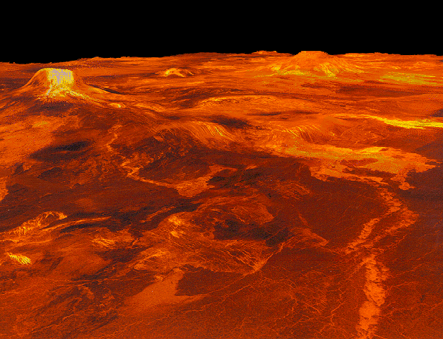
A portion of Western Eistla Regio is displayed in this three- dimensional perspective view of the surface of Venus. The viewpoint is located 1,100 kilometers (682 miles) northeast of Gula Mons at an elevation of 7.5 kilometers (4.6 miles). Lava flows extend for hundreds of kilometers across the fractured plains shown in the foreground, to the base of Gula Mons. We are looking to the southwest with Gula Mons appearing at the left just below the horizon. Gula Mons, a 3 kilometer (1.86 mile) high volcano, is located at approximately 22 degrees north latitude, 359 degrees east longitude. Sif Mons, a volcano with a diameter of 300 kilometers (180 miles) and a height of 2 kilometers (1.2 miles), appears to the right of Gula Mons. The distance between Sif Mons and Gula Mons is approximately 730 kilometers (453 miles). Magellan synthetic aperture radar data is combined with radar altimetry to develop a three-dimensional map of the surface. Ray tracing - rays as if from a light source are cast in a computer to intersect the surface - simulate a perspective view. Simulated color and a digital elevation map developed by Randy Kirk of the U.S. Geological Survey, are used to enhance small scale structure. The simulated hues are based on color images recorded by the Soviet Venera 13 and 14 spacecraft. The image was produced at the JPL Multimission Image Processing Laboratory by Eric De Jong, Jeff Hall, and Myche McAuley, and is a single frame a video released at a March 5, 1991, JPL news conference.

