NOTE: Click on the image to view it at its highest resolution.
P-42385 MGN-116
May 26, 1993
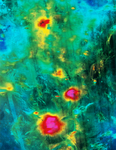
Magellan radar image and altimetry data are combined in this view of three volcanoes in the southern hemisphere of Venus. The colors represent elevations at the surface, with red and magenta being the highest and blue being the lowest. The area shown is centered at 33 degrees south latitude, 326 degrees east longitude, and is 2,300 kilometers by 1,650 kilometers (1,380 miles by 990 miles) in size. The data were acquired in September 1992 during the third and final phase of Magellan's radar mapping cycles. From north to south, the volcanoes are Ushas, Innini and Hathor Montes. Ushas Mons rises slightly less than 2 kilometers above the surrounding plains, and is marked by numerous bright lava flows and a set of north-south trending fractures. Innini, at 2.8 kilometers (1.7 miles), and Hathor, at 2.6 kilometers (1.6 miles), are taller than Ushas but are less distinct in the appearance of their volcanic deposits. The chain of three volcanoes is thought to result from a large zone of hot material upwelling from the Venusian mantle, a phenomenon known on Earth as a "hot spot." The image was produced by the Magellan Science Team at the Jet Propulsion Laboratory Multimission Image Processing Laboratory. The Magellan mission is managed by JPL for NASA's Office of Space Science.

