NOTE: Click on the image to view it at its highest resolution.
P-42356AC MGN-113
May 26, 1993
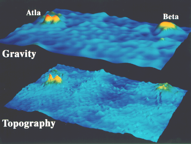
Magellan's fourth eight-month cycle of Venus mapping, which began in September 1992, was dedicated to collecting gravity data. The computer-generated perspective shown here compares gravity and topography over a region 12,700 kilometers by 8,450 kilometers and extends from longitudes 180 degrees east to 300 degrees east and latitudes 40 degrees north to 40 degrees south. The highlands of Beta Regio and Atla Regio, sites of rifting and large volcanoes, have corresponding high topography and high gravity. These areas are interpreted to be sites where hot mantle material is upwelling, forming "hot spots," similar to areas on Earth such as Hawaii. The two gravity highs at Atla correspond to the volcanoes Maat Mons, the higher of the two peaks, and Ozza Mons respectively. Gravity anomalies at Atla and Beta are the largest on Venus and these may be the sites of relatively young geologic features. In contrast to Earth, it is also seen that there is a near-perfect correlation between gravity and topography with anomalies, both positive (light blue) and negative (dark blue), being correlated with topographic highs and lows. This correspondence is interpreted to indicate that, relative to Earth, the formation of features on Venus is more strongly linked to fluid motions in the mantle. The Magellan mission is managed by the Jet Propulsion Laboratory for NASA's Office of Space Science.

