NOTE: Click on the image to view it at its highest resolution.
P-38360 MGN51
May 28, 1991
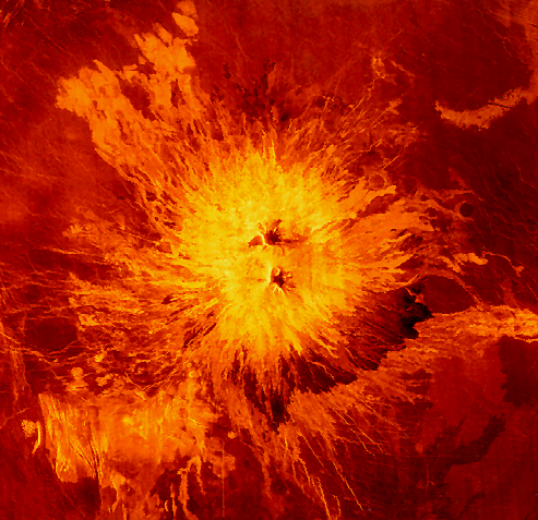
The volcano Sapas Mons, located in the broad equatorial rise known as Atla Regio (8 degrees north latitude, 188 degrees east longitude). The area shown is approximately 650 kilometers (403 miles) on a side. The volcano itself is about 400 kilometers (248 miles) across and 1.5 kilometer (0.9 mile) high. Its peak sits at an elevation of 4.5 kilometers (2.8 miles) above the planet's mean elevation. The flanks of the volcano are composed of numerous overlapping lava flows. The dark flows on the lower right are thought to be smoother than the brighter flows near the central part of the volcano. Many of the flows appear to have erupted along the flanks of the volcano, rather than from the summit. This type of flank eruption is common on large volcanoes on the Earth, such as the Hawaiian volcanoes. The summit area consists of a pair of flat-topped mesas whose smooth tops give a relatively dark appearance in the radar image. Also seen near the summit are groups of pits, some as large as one kilometer (0.6 mile) across.
These are thought to have formed when underground chambers of magma were drained through other subsurface tubes, leading to a collapse at the surface. A 20 kilometer (12.4 miles) diameter impact crater northeast of the volcano is partially buried by the lava flows. Little was known about the Atla Regio rise prior to Magellan. The new data taken in February 1991 shows the region to be composed of a least five large volcanic edifices such as Sapas Mons, which are linked by complex systems of fractures or rift zones. By analogy with similar features on the Earth, Atla Regio is thought to result from upwellings of large volumes of molten rock from the interior of Venus known as "hot spots."

