NOTE: Click on the image to view it at its highest resolution.
P-43249
December 6, 1993
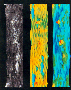
Since completing radar mapping of Venus in 1992, the Magellan spacecraft has been collecting data on the gravity field of the planet. By recording slight variations in the spacecraft's orbit as it passes over Venusian mountain belts, volcanoes and valleys, scientists are able to construct a "picture" of the distribution of density variations in the planet's interior. Those density differences, which create slight differences in the gravity field, also provide clues about the geological processes responsible for shaping features observed at the surface. These three perspective images show the structure of Venus at the surface, in the crust and in the mantle.
The upper plane shows surface features seen by Magellan's imaging radar "draped" over a three-dimensional representation of surface topography seen by the altimeter. Maxwell Montes (near 0 degrees longitude) is seen in the upper left, while the equatorial highlands of Aphrodite Terra stretch across the center of the image.
The central panel shows the location of density variations in the crust at a depth of 15 kilometers (9 miles), based on a model that accounts for both the topography and gravity field of the planet. The model, developed by Robert Herrick of the Lunar and Planetary Institute in Houston and Roger Phillips of Washington University in St. Louis, shows low density areas that are thought to represent thickened crust as blue and dented downward. On Venus, thickened crust is associated primarily with the strongly deformed highland areas known as tessera.
The lower panel shows the density structure within the mantle of Venus at a depth of 200 kilometers (120 miles). As on Earth, the mantle of Venus is believed to consist of dense rocky material that slowly flows in response to internal heating, bringing heat energy from the deep interior to the upper regions of the planet. The lower panel shows the upwelling areas as red and yellow and the downwelling regions as deep blue. Prominent mantle plumes are associated with Atla Regio (near the center) and Beta Regio (center right). Both of the sites contain large volcanic structures, consistent with the supply of hot mantle material from a deep plume.

