NOTE: Click on the image to view it at its highest resolution.
P-42393 MGN-119
May 26, 1993
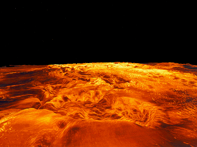
This computer-generated perspective view of the highland of Ovda Regio on Venus shows Magellan radar data superimposed on topography. This scene is made up of a compilation of radar images collected during all three of Magellan's eight-month mapping cycles. Simulated color, based on color images obtained by the Venera 14 and 15 landers, is used to enhance small-scale structure. The view is from west to east and vertical exaggeration is 22.5 times. Exaggeration of relief is a common tool scientists use to enhance relationships between structure and topography. Ovda Regio covers an area 6,300 kilometers by 2,100 kilometers (3,900 miles by 1,300 miles), rises over 3 kilometers (1.9 miles) above the surrounding plains, and is made up of complex ridge terrain, also know as tessera. Located in the foreground is a 400 kilometer by 250 kilometer (250 mile by 155 mile) oval depression that contains abundant faults and fractures. This feature is surrounded by radar-dark lava flows and is a site of volcanism and extension. The dark volcanic plains flood surrounding complex ridge terrain indicating that lava emplacement postdates the tesserae. The enhanced radar brightness of the complex ridge terrain in the background is due to both roughness on the scale of the radar wavelength and the presence of a metallic mineral in the surface. The Magellan mission is managed by the Jet Propulsion Laboratory for NASA's Office of Space Science.

