NOTE: Click on the image to view it at its highest resolution.
P-42392 MGN-118
May 26, 1993
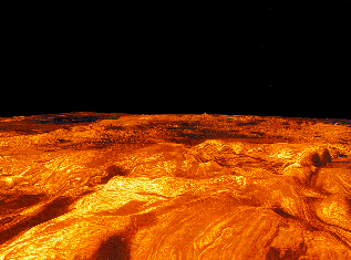
This computer-generated perspective view of the highland of Ovda Regio on Venus shows Magellan radar data superimposed on topography. This scene is made up of a compilation of radar images collected during all three of Magellan's eight-month mapping cycles. Simulated color, based on color images obtained by the Venera 14 and 15 landers, is used to enhance small-scale structure. The view is from the northeast looking to the southwest and vertical exaggeration is 22.5 times. Exaggeration of relief is a common tool scientists use to enhance relationships between structure (for example, faults and fractures) and topography. Ovda Regio covers an area 6,300 kilometers by 2,100 kilometers (3,900 miles by 1,300 miles), rises over 3 kilometers (1.9 miles) above the surrounding plains, and is made up of complex ridge terrain, also know as tessera. At the bottom right of this scene, along the northern edge of the highland, are a series east-west trending ridges that are interpreted to have formed by northwest-southeast-oriented compression. In several places the ridges are flooded by radar-dark (smooth) lava flows, indicating that volcanic activity postdates the formation of the ridges. The terrain in the interior of Ovda forms a chaotic pattern indicating multiple directions of deformation. The Magellan mission is managed by the Jet Propulsion Laboratory for NASA's Office of Space Science.

