
   Art is I; science is We.
      --Claude Bernard
The Magellan Radar Investigation Group (RADIG), selected by NASA in 1979 for the earlier VOIR mission, has the major responsibility for the radar science of the Magellan mission. To make sure that all aspects of the mission are capable of producing results that satisfy the scientific objectives, members of the RADIG have participated in most of the decisions about how the radar was designed and how it will be used. The RADIG has also been involved in laying out the data-processing procedures and in the decisions about how the data will be finally presented. One of its most important tasks, of course, will be to interpret the data and publish the results of its studies.
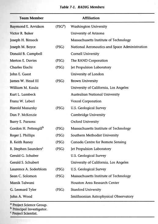
The RADIG is a collection of 26 scientists and engineers (see Table 7-1) with various perspectives and fields of expertise. Of these, five are foreign residents and supported by their own governments. An attempt will be made to coordinate each scientist's research activities so that, in sum, the major questions about the geology, geophysics, geochemistry, and geological history of Venus will be addressed.
Because of the large size of the RADIG membership, an executive subset -- the Project Science Group (PSG, identified in Table 7-1) -- has been chosen to represent RADIG; the PSG has met quarterly during the years prior to launch and will continue to meet throughout mapping operations.
The Data Products Working Group and the Mission Operations and Sequence Planning Working Group were established by the PSG to approve the Project's plans for data products and spacecraft/radar operations, respectively.
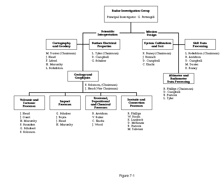
To accomplish its assignment, the RADIG is organized around six groups, each responsible for a general task (see Figure 7-1).
The Cartography and Geodesy Task Group will develop a latitude and longitude grid (known as a geodetic control network) for Venus by which Magellan maps of the planet may be coordinated and from which improved estimates of Venus' pole position and rotation rate may be derived.
The Surface Electrical Properties Task Group will work with the radar-scattering intensities obtained from both the SAR and altimetry operating modes, as well as with the thermal-emission data obtained from the radiometry mode, to determine the electrical properties of the surface.
The Geology and Geophysics Task Group is charged with meeting the scientific objectives that are the core of, and have largely justified, the Magellan mission. With 19 members, it is the largest of the task groups. Because of its size, it has been divided into four subgroups: (1) Volcanic and Tectonic Processes, (2) Impact Processes, (3) Erosional, Depositional, and Chemical Processes, and (4) Isostatic and Convection Processes. While these specialized processes provide a convenient framework, it is recognized that many, if not most, studies of the Venusian surface and interior will embrace more than one of them. Participation in these subgroups, and the consequent division of effort among the task groups' membership, will be fluid.
The System Calibration and Test Task Group monitors the radar test procedures and associated support equipment. While not carrying the prime responsibility for the performance of the radar system, this group provides advice from the users' point of view and will attempt to make sure that the calibration and performance of the radar meet the needs of the scientists.
The SAR Data Processing Task Group is charged specifically with monitoring the design of the algorithms and data flow involved in the handling of the SAR data by JPL's Multimission SAR Processing Facility.
Finally, the Altimeter and Radiometer Data Processing Task Group monitors the algorithms and data flow from the altimetry and radiometry experiments through the various processing steps to a final product.
Gravity and altimetry data from the Pioneer Venus Orbiter (PVO) mission (1978-1982) have provided the foundation for the present geophysical models of the interior of Venus. These data show a significant link between the variations in the gravity field of Venus and its topography; this link does not exist on Earth, the Moon, or Mars. This suggests that there are major differences between the processes acting within Venus and those operating within these other planetary bodies.
The primary objective of the Magellan Gravity Investigation Group (GRAVIG) is to enhance the existing data set so that more detailed gravity modeling can be performed.
However, unlike the radar experiment, which will receive high- resolution data during Magellan's initial 243-day mapping cycle, the gravity experiment will have to wait for an extended-mission phase to obtain its best data. The reasons for this are explained by the nature of the gravity data, the way in which these data are obtained, and the fact that the instrument of the gravity investigation is the Magellan spacecraft itself.
As Magellan orbits Venus, it will experience slight variations in speed caused by surface features and/or density variations within the planet. It is these changes in speed that form the basis of the gravity data.
To detect these variations, an Earth-based radio tracking system must precisely measure the spacecraft's velocity every few seconds, which requires Magellan's high-gain antenna to be pointed toward Earth so that it serves as a tracking transponder.
The highest-resolution gravity data will be obtained when the spacecraft is at its closest range (periapsis) to Venus. But during the initial mapping cycle, the time around periapsis will be dedicated to SAR imaging with the high-gain antenna pointed toward the surface of the planet, making it impossible to obtain high-resolution gravity data during that phase of the mission.
This does not mean that gravity data will not be obtained in the first mapping cycle. For approximately 2 hours of each mapping pass, high-altitude velocity data, which results in lower-resolution gravity data, will be acquired during the normal tracking activities while the spacecraft is transmitting radar data to Earth. These low-resolution data will be used in conjunction with PVO data to produce a revised model for the global gravity field of Venus.
Scientists from both RADIG and GRAVIG will work together to develop models of the interior of Venus. These models will incorporate SAR and altimetry measurements of the surface of the planet as well as deductions based on studies of the SAR images. These models, in turn, will help scientists develop scenarios for planetary formation and thermal history and will serve as an important source of information for comparative planetology studies.
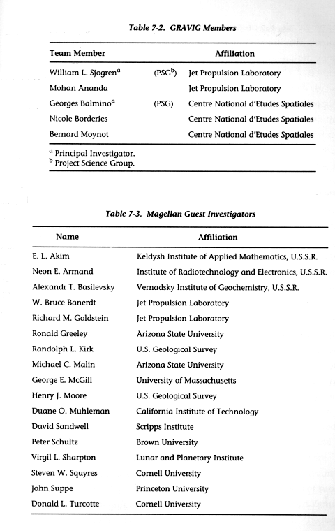
The Gravity Investigation Group is composed of two teams of American and French scientists (see Table 7-2), who will use different approaches to analyze the Magellan gravity data. The use of independent analysis techniques will provide important cross-checks on the calculations and will improve our confidence in the estimated gravity-field parameters and modeling results.
The French GRAVIG members reside in Toulouse, France. All costs of the French team, such as salaries, travel, and data analysis, are paid by the French government.
Seventeen additional science investigators (see Table 7-3) have been selected for the Magellan Project through the Magellan Guest Investigator Program. These scientists, representing a wide variety of disciplines, will be integrated into the Project's operations and science-analysis efforts.
![]() Chapter 8 - What's in a Name?
Chapter 8 - What's in a Name?
![]() The Magellan's Venus Explorer Guide
The Magellan's Venus Explorer Guide
