
   Venus, sweet mystical star
   Earchlike, but hotter by far
   No use to peruse
   Unless you can use
   Synthetic-aperture radar
               -- Anonymous
The SAR method of generating images is the heart of mission. Radar microwave energy will be used to observe the surface of Venus because the visually opaque clouds are transparent to the high radio frequency the radar transmits and receives. The technique of producing SAR images has been known for about 40 years. In most cases, the method uses a radar with a highly directional antenna on a movable platform-usually an aircraft or a spacecraft.
In the way a beam of light pierces darkness and reflects from objects to reveal their position, shape, and texture, Magellan's radar will use microwave energy to observe the surface of Venus. The high-gain and altimeter antennas will transmit the radar pulses (which are in an invisible part of the electromagnetic spectrum) and receive the reflected pulses (called echoes).
The word "aperture" in synthetic aperture refers to the size of the antenna that receives the echoes. As it is with a camera's lens, so it is with a SAR antenna, in that the larger the antenna (aperture), the higher the resolution of the resulting image. Because the antenna moves while it receives the echoes, special processing on Earth can simulate reception by a much larger antenna (i.e., a synthetic aperture). The distance Magellan travels while a surface feature is within the radar's field of view determines the functional size of the synthetic aperture.
The radar transmits energy in short pulses to one side of the platform, as shown in Figure 5-1. The direction along the track of the platform's motion is called azimuth; the direction across the track is called range. The SAR forms an image strip, with a width determined by the range dimension of the antenna's illumination and a length determined by the time the radar is in continuous imaging operation. The image strip (or swath) produced by Magellan will be about 25 kilometers (16 miles) wide and about 16,000 kilometers (10,000 miles) long.
The SAR technique requires the radar system to transmit and receive multiple pulses and echoes. If observed on an oscilloscope, one echo looks very much the same as the next, but they have subtle differences caused by the relative motion between the target and the radar. This motion creates an effect similar to the pitch change of a train whistle as a train passes by. This frequency change is called the Doppler effect; this effect is used to sharpen the resolution of an image, but in the azimuth direction only. Conventional pulse encoding and processing establish the resolution in range.
The principal source of noise in most SAR images is self-noise, called speckle. Speckle resembles salt-and-pepper-like changes in image intensity, like those in a poor-quality television picture. In SAR images, speckle is reduced by acquiring and processing the data in several "looks" (independent observations of the same target) and then adding the looks together. Most radar images, including Magellan's, are com- posed of at least four looks.
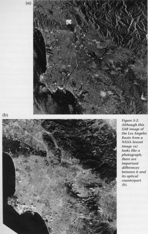
The SAR techniques for resolution improvement have been used to image the surfaces of Earth, the Moon, and Venus. An image produced by a SAR is very similar to a traditional aerial photograph, but there are some important distinctions. Areas that are bright in a radar image are not necessarily bright in a traditional photograph. Figure 5-2 shows a picture of the Los Angeles Basin in which the city of Burbank (upper left of center) appears bright in the SAR image. This brightness is caused by the alignment of buildings with the path of the radar platform. The local steep mountains appear to fold over toward the radar because of the shallow (near-vertical) angle between them and the radar. A SAR image shows no vegetation because trees and rocks reflect radar waves in a similar manner and it is difficult to distinguish between them. In most cases, surface roughness determines brightness in a radar image.
Radar images have additional characteristics that distinquish them from visible-light images or photographs. The characteristics of phtographs are determined mainly by the direction, relative to the camera, of the source illumination, the color of the subject, and the intensity of the light. Radar images are usually formed from a single-frequency radar; therefore, the images are usually shown in black and white, with these two extremes representing weak and strong signals, respectively. Also, the transmitter (light) and receiver (camera) are usually collocated.
SAR images can be formed using data gathered through clouds, at night, and from under dry, thin layers of sand. Because the brightness in a radar image is a function of surface roughness, angle of incidence, and electrical properties of the surface, radar-image interpretation is very different from that used for normal photographics images. The technique of radar-image interpretation is advancing as we gather data in a variety of ways and use ground truth (local observation) to increase our understanding of the interaction between the radar wave and the surface.
The radar sensor, Magellan's sole scientific instrument, will perform three distinct functions in Venus orbit: SAR imaging (to produce images of surface features), altimetry (to measure the height of surface features), and radiometry (to detect the natural thermal emissions from the planet surface).
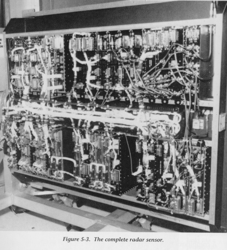
The Magellan radar sensor, shown in Figure 5-3, is composed of 17 units racked in a 1.5 x 0.9 x 0.3-meter (5 x 3 x 1-foot) enclosure and weighs 154 kilograms (340 pounds). Most of the units are in a redundant pairs for higher reliability. The sensor is located within the spaceraft's FEM and is used in combination with the high-gain and altimeter antennas.
A combination of factors led to the major mission contraints listed in Table 5-1. In many ways, these constraints dictated the design of the radar system and presented some pretty unique challenges. The high-gain antenna and the elliptical orbit were the most demanding challenges from the system-design view. The requirements imposed on the design were to meet all science objectives within the mission constraints and to make efficient use of the limited resources, especially the rate at which the spacecraft sent data to Earth.
    Table 5-1.  Magellan Mission Constraints
                That Influenced Radar Design
    ----------------------------------------------
    A single, spacecraft-fixed high-gain antenna
    An ellipitcal orbit
    Data rate and volume limitations
    Radar commanding from stored sequences only
    ----------------------------------------------
The high-gain antenna is excellent for telecommunications, but is uncommon for use as a SAR antenna. SAR antennas usually are larger and can be directed without moving the spacecraft. The fact that the antenna is rigidly fixed to Magellan's structure complicated the design of the spacecraft attitude-control system because the antenna, and thus the spacecraft, must be turned continuously during each orbit for mapping and communications with Earth, as well as for calibrations to aid navigation and to maintain proper spacecraft attitude. Additionally, the sharing of this antenna with the telecommunications subsystem reduced the number of possible design options that could have better tailored the antenna to the Magellan radar use.
The elliptical, 189-minute orbit is a definite departure from previous experience with orbiting radars, which usually operate in near-circular orbits. Since a SAR requires an extended series of pulses and echoes to form the synthetic aperture, the echoes must be interleaved between the transmitted pulses because the radar cannot transmit and receive simultaneously. To do this, the range to the surface must be predicted with high precision from second to second, which is not necessary for radar in a circular orbit. Magellan's 44-minute mapping peroid start near the north pole at an altitude of about 2,150 kilometers (1,336 miles), continues through periapsis at a 275-kilometer (171-mile) altitude, and finishes at a 2,400-kilometer (1,491-mile) altitude near 74 degrees S latitude. During this time, the radar system must compensate for Magellan's changing speed, changing altitude, and large variations in the planet terrain with adjustments in transmission rate and the echo-receive window. To do this, the system makes an incredible 3,000 changes in its operating mode during each mapping period. The commands that generate these changes are stored in the the spacecraft computers and are repeated during each orbit until a new set of commands is received from Earth every few days. The new commands take into account the gradual changes in the orbit and planet terrain.
The constraint of using only stored commands meant that the radar sensor could be of simple design, but that its operation would have to depend on such "outside" functions as navigation for orbit predictions and spacecraft attitude control for its high-precision operation and pointing information.
The inherently high data rate of the SAR system had to be reduced to satisfy the fixed data-rate constraint imposed by elements of the spacecraft's data-handling and transmission system. The record data-acquisition) rate is approximately 800 kilobits per second and the total volume is approximately 1.8 x 10^9 bits per orbit. Because of communications link limitations, this amount of data cannot be played back at the recorded rate; the tape recorders are therefore slowed by a factor of three, and 114 minutes of the 189-minute orbit are used for data playback. Additionally, the radar system employs a "burst-mode" data acquisition scheme (a data-reduction method discussed below) and passes the data through a digital filter that reduces the data rate but does not sacrifice image quality.
The piece de resistance of the burst-mode method of data collection is its ability to quickly change configurations to accommodate the elliptical orbit and make efficient use of the data volume that can be sent to Earth.
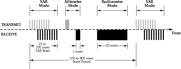
The SAR, altimeter, and radiometer modes share a time slot called the burst period, which lasts less than one second (see Figure 5-4). First, in SAR mode, the radar sends out a rapid burst of pulses through the high-gain antenna. Traveling at the speed of light, the pulses strike Venus' surface and echo back to the antenna. Because of the long burst duration of this mode, the echoes must be interleaved with the transmit pulses. The SAR mode lasts up to 250 milliseconds. After the last echo has been captured, the radar emits another, more-rapid burst of pulses, this time through the altimeter antenna. All of the altimetry pulses are sent before the first altimetry echo returns. This altimeter mode takes up to 25 milliseconds. After this mode, the radar switches back to the high- gain antenna for the radiometer mode. For the next 50 milliseconds, the radar becomes a passive receiver of microwave energy natually emitted from the planet surface.
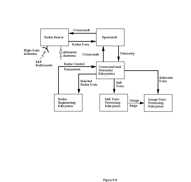
Magellan is not the first spacecraft to use SAR, but the design of its radar system is clearly the most advanced for its intended purpose. In addition to the flight equipment (radar sensor and antennas), the radar system includes the Earth-based elements shown in Figure 5-5. Radar-system commands are generated through a computer program called Radar Mapping Sequencing Software (RMSS), which is specially tailored to optimize the data-collection geometry and calculate the nearly 3,000 commands required to operate the radar sensor during mapping. The radar commands are part of the command loads discussed in Chapter 12. Also, a portion of the data returned to Earth, along with engineering information about voltages, currents, and temperatures, is sent to the Radar Engineering Subsystem, where the data-collection process and the health of the sensor can be monitored.
The Earth-based systems also include the SAR Data Processing Subsystem (SDPS), which accepts the raw radar data on magnetic tape. These data are still just the raw-data echoes, which are combined in a complex way (creating the synthetic aperture) to produce image strips. Radiometer data are also processed in this subsystem.
The Image Data Processing Subsystem (IDPS) takes the image strips in electronic form (on tape or discs) and mosaics these strips into large-area-coverage maps of the planet surface. The radiometer data are likewise mosaicked into maps. The altimetry data are accepted by the IDPS, and both raw-data processing and mosaicking are performed to produce large-area-terrain height maps that will complement the image data mosaics from the SAR.
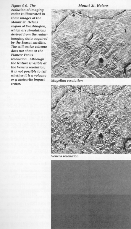
Engineers from the Hughes Aircraft Company of El Segundo, Califonia, and from JPL folded in all of these mission constraints; what emerged was a fairly simple radar sensor, an innovative design for the system that operates it, and a SAR-image resolution of the Venusian surface that is higher than any achieved to date (see Figure 5-6).
![]() Chapter 6 - Ferdinand Magellan - The Project's Namesake
Chapter 6 - Ferdinand Magellan - The Project's Namesake
![]() The Magellan's Venus Explorer Guide
The Magellan's Venus Explorer Guide
