
   Man masters nature not by force but by understanding.
   This is why science has succeeded.
                                 -- Jacob Bronowski
The all-enveloping, continuous cloud cover around Venus has prevented optical imaging of the surface from spacecraft, which has slowed our understanding of its surface processes. The limited data we have acquired from spaceborne and ground-based observations, however, have been sufficient to indicate that the nature of the Venusian surface is indeed provocative.
When photo mosaics of the Magellan radar data are available to Magellan scientists, their eyes will eagerly search for details that may answer some very basic questions about the geology of Venus, such as
Of course, the most interesting answers may come from questions not even asked yet!
With the addition of gravity-field measurements, Magellan scientists hope to improve their understanding of the geophysics of Venus by determining how mass is distributed within the planet and by ascertaining the nature of the interior processes and how they affect the surface features.
Magellan will maneuver into orbit around Venus on August 10, 1990. However, the mapping phase will not begin for 22 days. During that time, the spacecraft and the radar sensor will be tested and the orbit will be adjusted, if necessary. Magellan's orbit will be fixed inertially in space, which means the spacecraft will orbit the planet in a plane that is fixed, relative to the stars. Venus will rotate beneath the orbit of the spacecraft 1.5 degrees a day, or about 150 kilometers (93 miles). Thus it will take exactly one Venus rotation (243 Earth days) to conduct the mapping phase. The data will be acquired in strips about 25 kilometers (16 miles) wide and about 16,000 kilometers (10,000 miles) long, as the spacecraft moves from the north pole to about 74 degrees S latitude.
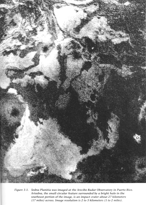
The map coordinate system used for measuring longitude on Venus is different from that used on Earth. On Earth, longitude (an imaginary line stretching from pole to pole) is measured from a starting point (the prime meridian) at Greenwich, England (near London), toward the east and toward the west with increasing values in degrees until east meets west at the 180-degree point (the dateline), which is diametrically opposed to Greenwich. On Venus, longitude is measured from 0 to 360 degrees with the prime meridian centered within a small impact crater named Ariadne, located in Sedna Planitia (see Figure 3-1). There is an arbitrary convention that determines the direction of increasing longitude on planetary bodies other than Earth: longitude shall be measured in a direction opposite to that in which the planet rotates. Because Venus rotates in a clockwise direction as viewed looking down on the north pole, longitude on Venus increases in numerical value toward the east from the planet's prime meridian.
For the remainder of this chapter, we will take an imaginary journey around Venus and discuss some of the important facts and questions about many of the surface features. So, before reading further, we suggest you remove the map of Venus from the inside back cover and navigate along with us. If you trip over some of the terminology, help is near at hand in "Glossary of Geological Terms".
Magellan will begin mapping at 307 degrees E longitude over the western edge of Ishtar Terra, a highland region about the size of Australia (see Figure 3-2). During the next several weeks, a high volcanic plateau, called Lakshmi Planum, will be within view. Lakshmi is situated nearly 5 kilometers (3 miles) above the mean radius of Venus and is surrounded by mountain belts (ranges): Akna Montes (west), Freyja Montes (north), Maxwell Montes (east), and Danu Montes (south). All of these mountain belts show intense deformation (faulting and folding) of the planet's crust, similar to deformed rocks seen in mountain belts on Earth. Maxwell Montes contains the highest point on Venus; its peak towers more than 11 kilometers (7 miles) above the lowland plains. Two large volcanic calderas, Colette and Sacajawea, are located in the center of Lakshmi Planum and are surrounded by long volcanic flows. The origin of the high plateau and mountain belts is controversial. One theory suggests they formed over a hot plume of material rising from the interior of the planet, while another says the region is being compressed (pushed together) from all sides, resulting in material descending into the interior of the planet. Perhaps the Magellan images will reveal evidence of plate tectonics, a process that could have produced the large amounts of compression needed to form the mountain belts.
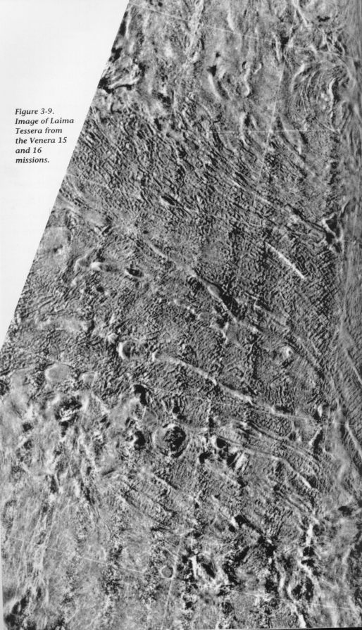
Lakshmi and its high mountains are surrounded by regions of tesserae terrain named Fortuna, Atropos, and Clotho Tesserae (also shown in Figure 3-2). Tesserae terrain, which was first detected by the Soviet Venera 15 and 16 spacecraft in the early 1980s, is characterized by complex intersecting ridges and grooves. This terrain may have been formed by large blocks of material sliding and collapsing down slopes, pulled by the force of gravity. In the extremely high-temperature Venus environment, rock can behave more like a fluid, unlike the rigid behavior of rocks found on Earth.
Magellan will next image Guinevere and Sedna Planitia (see Figure 3-1), south of Lakshmi Planum. These low-lying regions have abundant small volcanoes and long lava flows. We hope the lava flows will provide new and exciting information about the electrical properties of the materials that make up the surface of these plains. (Determining the electrical properties of surface material can tell us, among other things, the ratio of rock to soil.) Unlike similar plains on the Moon, Mars, and Mercury, the Venusian plains are relatively free of impact craters.
The Soviets have successfully landed several spacecraft in the plains regions. Seven of the landers conducted chemical analyses of rocks, which indicate a composition similar to that of terrestrial basaltic volcanic rocks. The Venera 9 lander gave us our first glimpse of the Venusian surface when, in 1975, it relayed the panoramic view shown in Chapter 1, Figure 1-2. In 1981, the Venera 13 lander provided the first color images of the surface of Venus. These photos from the Soviet landers are the only available local observations, and they will be most useful in interpreting the high-resolution Magellan radar images.
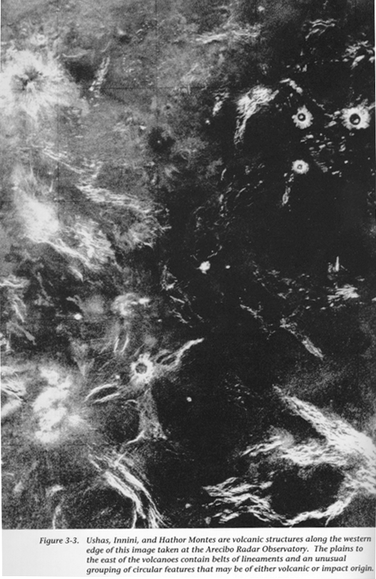
Moving now to the southern hemisphere, some of the first features that will be imaged are a group of high peaks called Ushas, Innini, and Hathor Montes (see Figure 3-3). These peaks are interpreted as being large shield volcanoes. Earth-based radar images show that the peaks are surrounded by lava flows. All three features are located on broad raised topography indicating that they may be underlain by a hot mantle plume, similar to that underlying the island of Hawaii. This group of peaks may be similar to Imdr Regio, centered at 43 degrees S latitude and 210 degrees E longitude, which will be imaged by Magellan in March 1991.
The first major impact crater that will be imaged is Meitner (see Figure 3-4), centered at 56 degreesS latitude and 322 degrees E longitude. Meitner, a multiringed basin about 85 kilometers (53 miles) across, may be similar to large multiringed basins on other planetary bodies, such as Orientale Basin on the Moon. It is believed that many of these basins on other planets have been the cause of volcanism. Has this been the case on Venus? Geologists also wonder about the effect of the hot Venus environment on impact basins. It is believed that Meitner may be relatively shallow because, under the influence of this heat, the crust "flowed away" with time. The plains to the east of Meitner contain complex belts of lineaments (also shown in Figure 3-4). Magellan data will be studied to determine whether these lineaments are ridges or grooves.
Again in the north, Magellan will be back covering Ishtar Terra, moving over the high Maxwell Montes region (see Figure 3-5). Near the high peak of Maxwell lies a 70-kilometer- (43-mile-) diameter circular depression called Cleopatra. The origin of Cleopatra is another subject of friendly debate. Some scientists argue that the crater was formed by a collapse that followed a giant volcanic eruption, while others believe that it is the result of a meteorite impact. Volcanism is evident, but it may have been triggered by an impact.
Fortuna Tessera (also shown in Figure 3-5) lies to the east of Maxwell Montes; it is a jumbled region of differing types of tesserae terrain. One theory of its origin suggests that different pieces of tesserae terrain have been pushed together to form this complex region, sort of like bumper cars slammed up against Maxwell Montes.
To the south of Fortuna Tessera in Bereghinya Planitia, Magellan will image arachnoids (see Figure 3-6), another class of features first identified in the Venera 15 and 16 data. We hope to gain an understanding of why arachnoids formed, what caused the odd weblike lineaments surrounding the structures, and why the features tend to form in clusters.
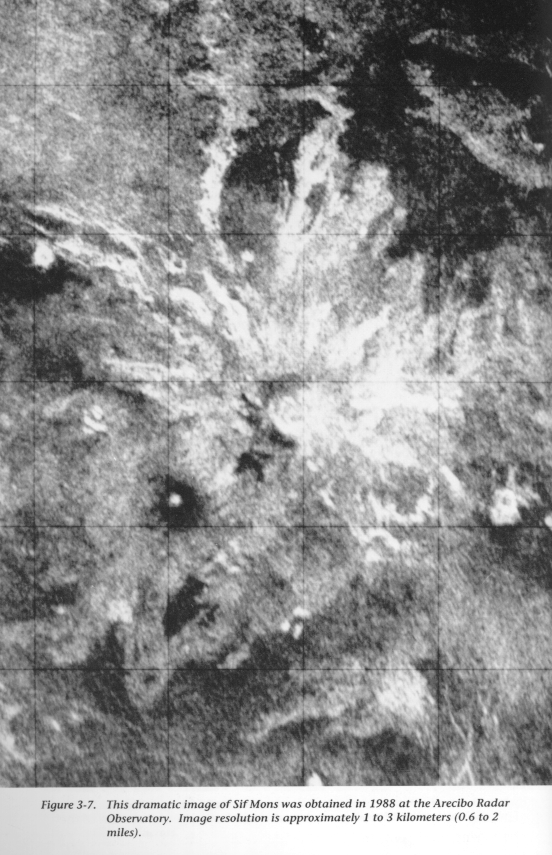
Moving south of Bereghinya Planitia, we come to Sif Mons, a peak in Eisila Regio (see Figure 3-7). Its dark central caldera, which may contain pools of lava, is surrounded by extensive flow features that seem to cascade down its flanks. Is this feature now active? If the Magellan Project is extended for additional 243-day mapping cycles, scientists could compare images of volcanic features, such as Sif, to detect current volcanic activity.
Traveling again into the southern hemisphere, we come across the highland region of Alpha Regio (see Figure 3-8). Previous radar images indicate that this is a region of tesserae. Tesserae tend to occur in rather polygonally shaped plateau regions, as well as in small islandlike regions in the plains. Do tesserae underlie all of the plains? Some geologists believe regions of tesserae have formed as the result of compressional forces, while others believe they were created at a spreading center and moved laterally out into the plains. Alpha Regio is similar in size and appearance to Tellus Tessera, centered at 35 degrees N latitude and 82 degrees E longitude, a region that will be imaged in early December 1990.
The topography south of Alpha Regio, called Lada Terra, seems to be a relatively high region that may be similar to Ishtar Terra. Farther south still lies the mysterious south polar region, an area that has never been imaged. Although Magellan's coverage during the first mapping cycle will not extend all the way to the south pole, it will reach much farther than that of any previous spacecraft, allowing us to see if Lada also contains mountain belts and regions of tesserae. (Magellan's ability to map the south pole during additional mapping cycles is discussed in Chapter 11.)
Returning north again, scientists will begin receiving images of Laima Tessera (see Figure 3-9) located at 50ˇN latitude and 40 degrees E longitude. Laima differs from other regions of tesserae in that it has a distinct set of ridges intersected at right angles by long linear troughs. The morphology of this region is similar to that of the Earth's ocean floor, leading some scientists to postulate that Laima formed at a spreading center.
South of Laima is a small highland region called Bell Regio, which has a high volcanic peak named Tepev Mons (see Figure 3-10). Bell and Tepev will be imaged by Magellan in mid-November 1990. Bell is also thought to be underlain by a hot mantle plume. On Earth, most of the heat generated inside the planet by the decay of radioactive elements is lost through the process of plate tectonics. On Venus, the internal heat may be creating many mantle plumes that form highland regions and volcanoes. High-resolution gravity data, which would be obtained during extended mission cycles, would help scientists solve this puzzle.
Also in mid-November 1990, Magellan will image what is probably the most actively debated region on Venus: Aphrodite Terra. Approximately the size of Africa, Aphrodite straddles the equator, is over 10,000 kilometers (6,214 miles) long, and is made up of four smaller highlands: Ovda, Thetis, Atla, and Ulfrun Regiones. Some geologists believe that Aphrodite is a spreading center, a linear zone where new crust is created and spread out laterally to the north and south, similar to the midocean ridge spreading centers on Earth (see Figure 3-11). Others believe that Aphrodite is underlain by mantle plumes with little or no crustal spreading.
The first areas of Aphrodite Terra that Magellan will cover are Ovda and Thetis Regiones, which are high plateaus cut by a central trough. Scientists will look for evidence that material has moved north or south away from this trough, similar to the way Iceland is being split by the Mid-Atlantic Ridge. If Thetis and Ovda are sites of new-crust production, the age of the surface should increase away from their central axes. In other words, Aphrodite would be the youngest region and Ishtar Terra (to the north) and Lada Terra (to the south) would be the oldest. Is there evidence of volcanism and transform faulting in this region? Can we identify anything like the plate boundaries we see on Earth?
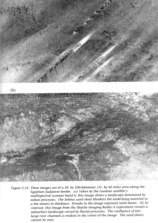
South of Aphrodite is a lowland plains region called Aino Planitia. These plains are too far east to be imaged by Earth-based radar (because Venus always shows the same face toward Earth when it is near enough for the best study) and are south of the Venera spacecraft radar coverage. Thus, little is known about them. Are they ancient terrain characterized by many impact craters, or are they like the relatively young volcanic plains to the north? Airborne radar observations of the Sahara Desert on Earth penetrated through the top thin layers of sand and detected evidence of previous wetter climates (see Figure 3-12). Will the Magellan images show the present surface of the Venusian plains, or will we be looking through the top dry layers of regolith to an older subsurface layer? If there is evidence that water existed in Venus' past, we can determine when the greenhouse effect turned the planet into a place where no human can survive.
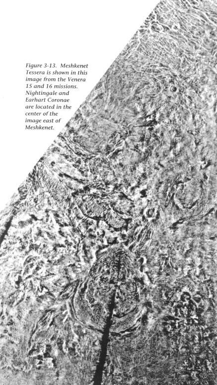
Heading north again, we see to the east of Fortuna Tessera a fragmented region of tesserae called Meshkenet Tessera (see Figure 3-13). This terrain appears to be flooded by volcanism from the surrounding plains, and thus seems to be relatively old. To the east of Meshkenet lie several large circular structures called coronae. Nightingale Corona, 560 kilometers (348 miles) in diameter, is surrounded by a ring of ridges over 1.5 kilometers (0.9 mile) high. Coronae are believed to form over hot mantle plumes that rise from the interior of the planet. Coronae range in size from 170 to 1,000 kilometers (106 to 621 miles), with most of the features lying in clusters to the west and east of Ishtar Terra.
To the south of Thetis Regio in Aphrodite lies Artemis (see Figure 3-14), one of the most enigmatic features on Venus. Magellan will begin mapping Artemis in late November 1990. Artemis is a large circular feature about 2,600 kilometers (1,616 miles) in diameter, with relatively raised topography surrounded by a deep narrow trough. Scientists wonder if this is the largest corona on Venus, or whether this region was similar to a high plateau, like Thetis, which has relaxed or flowed away with time.
Atalanta Planitia, centered at 64 degrees N latitude and 163 degrees E longitude, is a basin that extends for 1,500 kilometers (932 miles). Data from the Pioneer Venus spacecraft indicate that several areas within Atalanta contain rocks with unusual and/or unknown composition. There may be different erosional conditions or volcanic compositions that would produce these rocks; Magellan may detect sand dunes and wind streaks that result from eolian processes.
South of Atalanta is the central region of Aphrodite, which contains several deep troughs. Two of these troughs are called Dali and Diana Chasmata, and they contain some of the lowest elevations on Venus. Large troughs like these are thought to be rifts -- areas where the crust or upper layer of the planet are pulled apart by extensional forces. The Soviet Vega 1 and 2 spacecraft landed on the southern and northern flanks of this region of Aphrodite and measured rock compositions similar to those of igneous rocks on Earth.
East of Atalanta Planitia lies Vinmara Planitia (see Figure 3-15), which will be imaged by Magellan in February and March 1991. This is a low-lying plains region with intertwining belts of ridges that extend for thousands of kilometers. There is much debate over whether these ridges are formed by extension -- material being pulled apartŃor by compressionŃmaterial being pushed together. Scientists will search the Magellan images for features that will disclose the origin of these ridge belts, and perhaps why they occur as a fan-shaped group in this region.
South of Vinmara, on the eastern end of Aphrodite, are two elongate highlands called Atla and Ulfrun Regiones. Atla and Ulfrun contain many high peaks thought to be volcanic in origin, but which have never been imaged at high resolution. Will they be characterized by lava flows, like Sif Mons in Eisila Regio, or are they long-dormant, eroded volcanoes?
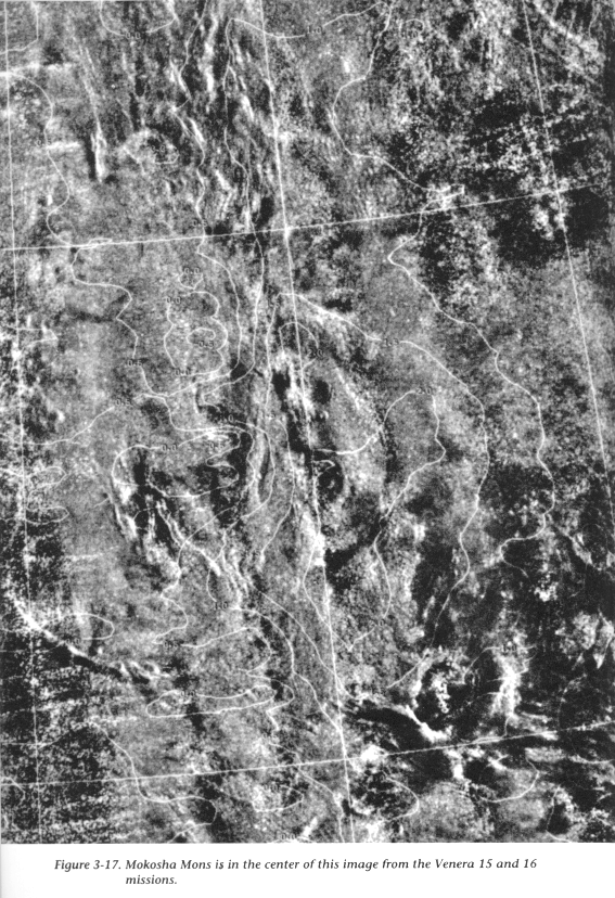
Back up north again, Magellan will image several large coronae and volcanoes in March 1991. Bachue Corona (see Figure 3-16) is located in Metis Regio and is raised over 2 kilometers (1 mile) above the surrounding region. Bachue may be a corona in the process of forming, since it is only partially surrounded by a ring of ridges. Mokosha Mons, a little to the south of Bachue, is a 350-kilometer- (217-mile-) wide volcanic structure (see Figure 3-17). It has a complex central caldera surrounded by many lava flows. Mokosha probably formed over a long period of time, with multiple phases of eruptions, similar to large complex volcanoes on Earth. South of Mokosha and heading east out of Aphrodite are several long, linear troughs named Hecate and Parga Chasmata. These troughs have raised rims and extend for thousands of kilometers, a configuration similar to the troughs in central Aphrodite. The troughs may be comparable to the long linear rifts that lie along the midocean ridges on Earth. Hecate Chasma leads into Asteria Regio, a small highland region of unknown geology that will first be imaged in early April 1991.
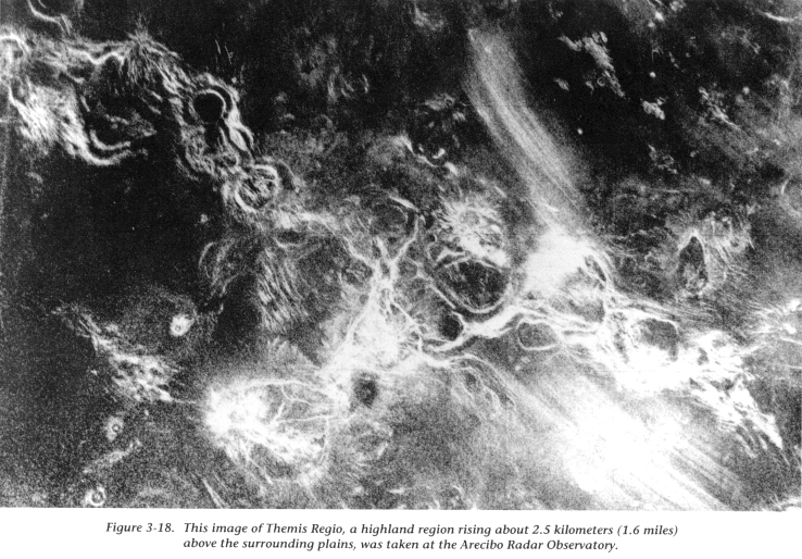
Southeast of Pargo Chasma are the strange circular features of Themis Regio (see Figure 3-18). Themis is composed of over seven multiple-ring features, with the diameter of the outer ring measuring over 300 kilometers (186 miles). Are these large impact craters, coronae, or something completely different? Coronae in the northern hemisphere do not tend to form in chains as these features do. Perhaps the Themis features are formed by large bodies of molten rock rising along a zone of extension.
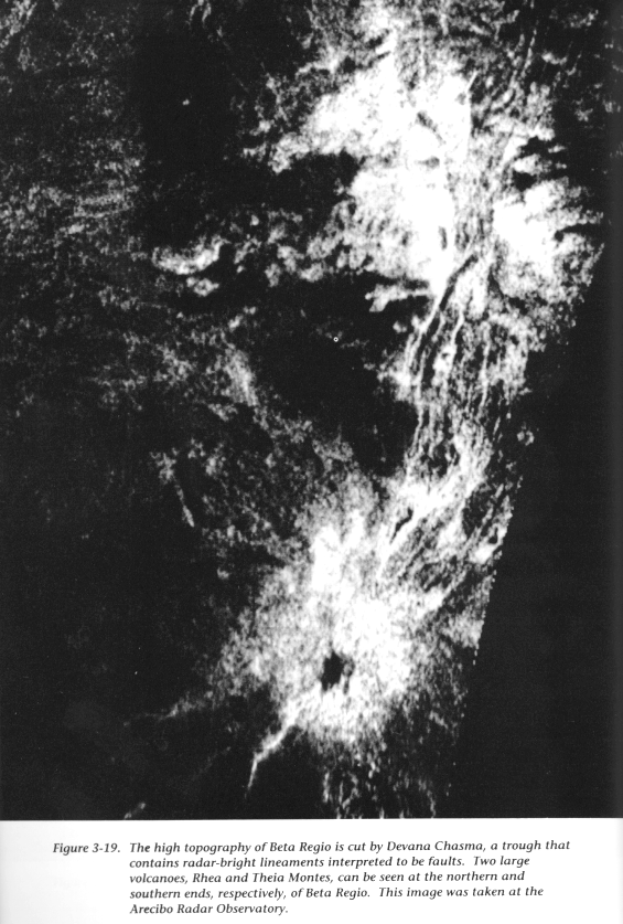
Finally, at the end of the 243-day mapping cycle, Magellan will be situated at 276 degrees E longitude, over the region where it first came into orbit. Here it will map Beta and Phoebe Regiones, two highland regions in the equatorial zone that are characterized by a north-south trough, Devana Chasma (see Figure 3-19). Beta is similar in size and general morphology to the East African Rift Zone on Earth, a region where the crust of the planet is being pulled apart. Scientists will use Magellan data to determine how much extension has taken place. Some scientists also believe that Beta is the most likely place on the planet to detect active volcanoes.
Over the course of one Venus rotation (243 Earth days), the Magellan spacecraft will map most of the surface with detail that exceeds that of the best previous radar images. The resultant maps will reveal the traces (if they exist) of many fundamental planetary forces: volcanism, wind, water, and meteorite impacts -- in short, all the processes that determine a planet's history and shape its face. By giving us this new information, Magellan will not only tell us more about Venus, our nearest planetary neighbor, but perhaps will provide the insight we need to fully understand the forces that continue to shape our own Earth.
![]() Chapter 4 - The Magellan Spacecraft
Chapter 4 - The Magellan Spacecraft
![]() The Magellan's Venus Explorer Guide
The Magellan's Venus Explorer Guide
