
   Hear ye not the hum of mighty workings?
           -- John Keats
When you think about the Magellan mission, you might be inclined to focus on the marvels of the spacecraft and the radar, on the thrill of finally unveiling some of the mysteries of Venus, or on the fact that it's wonderful to be alive during this historic period of solar-system exploration. But you might not think about people, plans, and coordination. This chapter encourages you to do so, for it's about the people of Magellan and how they get the job done.
The Magellan scientists have met for many years on a quarterly basis to plan the mapping coverage requirements that will best meet the scientific objectives of the mission, to participate in key decisions about the radar system, to help lay out data-processing procedures, and to decide how the data can best be presented for study and public release. Since most of the scientists are not employed at JPL, their interests in these activities are represented within the Project by the five members of the Mission Operations Science Support Team.
The scientists have sharpened their skills in interpreting radar images by participation in workshops and in field trips to sites that provide a direct comparison of geologic features with SAR images of the areas visited.
Most of the Magellan scientists will be in residence at JPL at various times throughout the 8-month mapping cycle. The Science Mission Support Area on the second floor of Building 230 has been equipped with sliding display boards, light tables, and sufficient flat surfaces to accommodate large mosaics and maps. Offices for the various science disciplines contain computer workstations that will allow investigators to access, view, and manipulate the radar imaging data. All in all, the environment is conducive to image analysis and the exchange of ideas as the scientists strive to understand the newly acquired information about the geology and geophysics of Venus.
However, before the scientists can get their hands on the data, an enormous amount of planning will be carried out by the aptly named Mission Planning Team (MPT), whose nine members are located at JPL and Martin Marietta. A few of this team's tasks include planning major mission events such as launch, cruise, trajectory-correction maneuvers, spacecraft and/or radar-system tests and calibrations during cruise, Venus orbit insertion, and the activities of the in-orbit checkout phase.
Precision is the key word when describing the activities of the 12-member Navigation Team (NAV). Working in close concert with the MPT, the Magellan navigators provide precise information on the spacecraft's location as it travels to Venus, on how much rocket thrust will accomplish a needed trajectory-correction maneuver, and on the precise location of the spacecraft as it approaches the planet and is readied for orbit insertion.
The activities of Magellan's Ground Data System (GDS) Office extend to just about every element within the Project. Based on the unique needs of the various Project teams, the 85 members of the GDS develop, test, upgrade, and maintain the automated tools required for the team functions. Nearly every activity mentioned in this chapter has been affected by the efforts of the largest team within the Project.
Although Magellan is a highly sophisticated robot, it depends on ground personnel to tell it precisely what to do and when to do it. Since it is not practical to send instructions to the spacecraft every day, and because Magellan is equipped with its own internal clock, a set of commands covering a period of several weeks during cruise (one week during mapping) is sent to its computer a few days before the command sequence begins. Several teams within the Project work together to build the sequence of spacecraft and radar-instrument commands. Coordination and cooperation are the key elements in this process.
Creation of the Mission Plan marks the beginning of sequence development. The Plan and an associated Mission Profile (a graphic chart that shows the desired activities and approximately when they are to occur) are developed by the Mission Planning Team, based on inputs from other teams within the Project. For example, inputs from the Spacecraft Team (SCT) specify certain activities necessary to operate the spacecraft. Since the mapping activities will be of a repetitive nature, the inputs to the sequencing process will typically cover a 4-week period or four stored sequences.
When the final inputs are ready, they pass to the Mission Sequence Design Team (MSDT), whose 12 members are located at JPL and Martin Marietta. This team builds a baseline sequence, which is a minutely detailed timeline of the desired activities. A typical sequence will span 8 days of activities or 61 orbits around Venus, and includes an extra day that is planned not to be used. (Incidentally, a complete, printed timeline can span over 5 meters [17 feet] in length.) The MSDT task includes resolving conflicts among specific events and figuring out how much antenna tracking coverage is required for the activities. This detailed timeline lays the groundwork needed by the SCT to develop engineering sequences that will execute the desired activities.
The SCT, whose 68 members are resident at JPL and Martin Marietta, is responsible for the health and optimal use of the spacecraft. Through continuous analysis of engineering telemetry, the SCT monitors the status of Magellan. In addition to developing sequences into the final command load that will be sent to the spacecraft, the SCT ensures that the instructions do not violate spacecraft operating constraints and that they will fit into the spacecraft�s computer memory.
The 17-member Radar System Engineering Team (RSET) from the Hughes Aircraft Company, but in residence at JPL, monitors the health and performance of the radar sensor, develops the detailed instructions for its operation, and ensures that commands to the sensor do not violate spacecraft and/or sensor operating constraints.
Once the final command load is built and verified and has received approval by the Mission Director, a final step by the SCT converts the load from a text file to the stream of bits (1s and 0s) that will be sent to the spacecraft.
Throughout the building of a command load, the five-member Mission Operations and Command Assurance Team provides independent checks of the overall quality of the commanding process and suggests improvement where needed.
The sequence design process, from handoff of the mission planning input through transmission to the spacecraft, takes approximately 6 weeks of technical interaction, give and take, teamwork, reviews, and decisions.
The Mission Control Team (MCT) of about 20 members located at JPL is the real operator of the spacecraft. In addition to controlling all transmissions to the spacecraft, the MCT receives all telemetry at JPL from the spacecraft. It monitors real-time spacecraft performance and verifies the proper execution of transmitted sequences.
A particularly important task of the MCT is scheduling the resources that provide the path of communication to and from the spacecraft. This activity begins months in advance of the requested coverage dates and involves coordination of Magellan requirements with operational organizations outside the Project, such as the DSN, JPL's Multimission Control and Computing Center (MCCC), and the NASA/Goddard Space Flight Center's NASCOM communications network. These resources are essential for certain spacecraft activities and yet they must be shared with other flight projects such as Galileo, Voyager, and Pioneer. With such a demand for DSN services, it's no wonder that the scheduling process is indeed involved.
Representatives of the MCT, other flight projects, and the DSN regularly meet to negotiate equitable allocations of antenna tracking support. The amount of tracking time acquired by a project is dependent on the relative importance of that period to its mission. For example, Magellan will receive simultaneous coverage from two tracking antennas during the critical Venus orbit-insertion maneuver on August 10, and will have continuous tracking coverage during the 243-day mapping phase of the mission.
The continuous 24-hour tracking of several spacecraft requires Earth-based antenna sites at strategic locations that compensate for the Earth's daily rotation. The Deep Space Communications Complexes (DSCCs) in Spain, Australia, and California are approximately 120 degrees apart in longitude, which ensures continuous observation and suitable overlap time for transferring the spacecraft radio link from one site to the next.
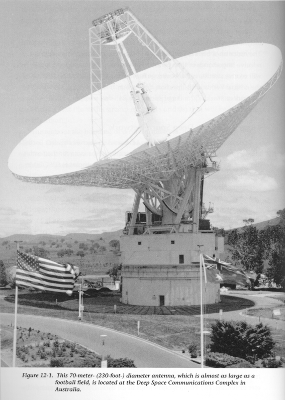
The Australian DSCC is located 40 kilometers (25 miles) southwest of Canberra near the Tidbinbilla Nature Reserve. The Spanish site is 60 kilometers (37 miles) west of Madrid at Robledo de Chavela. The Goldstone complex resides on the U.S. Army's Fort Irwin Military Reservation, about 72 kilometers (45 miles) northwest of Barstow, California. The international staff required to operate the DSN numbers over 1,100 people.
The Network Operations Control Center (NOCC), which controls and monitors operations at the three DSCCs, is located at JPL. The Network's Ground Communications Facility (GCF) at JPL provides and manages the communications circuits that link the complexes, the NOCC, and the various remote flight project operations centers at JPL.
Each DSCC consists of four deep-space stations equipped with ultra-sensitive receiving systems and large parabolic dish antennas (see Figure 12-1). There are two 34-meter- (111-foot-) diameter antennas, one 26-meter- (85-foot-) diameter antenna, and one 70-meter- (230-foot-) diameter antenna. The 70-meter antennas at all three DSCCs were extended from their original 64-meter (210-foot) diameters to increase their sensitivity in preparation for the Voyager 2 spacecraft encounter with Neptune in August 1989.
The high data rate (268.8 kilobits per second) and the precise navigation requirements associated with Magellan's mapping phase will impose a support load on the DSN as heavy as or heavier than any during the past 30 years. To meet this challenge, the DSN has implemented major modifications to its telemetry and navigation systems. Equally important is the operational support required during the mapping phase. To acquire all high-rate mapping telemetry and generate the requested navigational data during Magellan's 8-month mapping phase, the DSN will be required to provide, on a daily basis, approximately 36 hours of antenna and antenna-related support.
During this time, the DSN will also support Galileo, Ulysses (to be launched in October 1990), Voyagers 1 and 2, Pioneers 10 and 11, and the International Cometary Explorer (ICE). Magellan, Galileo, and Ulysses will be in their prime mission phases and will have the highest priority. However, the Pioneers, Voyagers, and ICE will continue to have well-defined scientific objectives. Even with a lower priority, they will have substantial "survival" requirements that must be met. In addition, a significant amount of time must be made available for Network maintenance and new-implementation test and training.
The DSN has estimated that Magellan support losses, depending on the date within the 243-day mapping phase, will be from zero to a maximum of 5 hours per day. Any losses will be the result of conflicts with other flight projects, but primarily those with the Galileo prime requirements and Pioneer 11 and ICE survival requirements. The overall impact of these losses on Magellan is relatively slight. The losses will be mostly evidenced in a reduction of station overlap time; therefore, continuous telemetry coverage will be essentially unaffected. Since the primary loss will be a reduction of some opportunities to acquire a certain type of navigation data, the DSN has developed an alternate Doppler data type that is expected to compensate for this loss.
Once the sequence command load is ready and the communication resources are scheduled, command operations get under way.
The Operations Planning and Control Team (nine members) moves the command file (via magnetic tape) to the Magellan Command Subsystem at the MCCC, where the file is formatted to GCF standards. The GCF electronically transmits the command file to the appropriate DSCC via a combination of communications satellites and conventional surface and undersea circuits (see Figure 12-2). The DSN Operations Team at the DSCC checks the file for correct reception, removes the GCF formatting bits, and routes the file to the appropriate antenna for transmission to the spacecraft. Traveling at the speed of light, the first command will reach the spacecraft in 14 minutes; Magellan's acknowledgment of receipt will require another 14 minutes to reach ground engineers.
The data received during Magellan's cruise and mapping phases are of enormous value. The telemetry includes engineering data that indicate the performance of the spacecraft and its subsystems. This information is identified with spacecraft time so that the state of the spacecraft at any given time can be completely reconstructed.
The navigation data collected during the cruise period indicate whether the spacecraft is on the right course for Venus. Mapping-phase navigation data will provide precise knowledge about Magellan's orbit, which will be used to adjust the radar commands for optimal use of the radar sensor.
The radar-mapping data in the telemetry results from playback of the tape recorders during each orbit. These data will eventually be processed into photo products for interpretation by Magellan scientists.
As the data stream from Magellan arrives at the DSCC, it is recorded on magnetic tape. From this point on, the recorded data are called Original Data Records (ODRs). The radar imaging, altimetry, and radiometry ODRs, which include a certain amount of embedded engineering data, are shipped to JPL, since the high data volume exceeds the capacity of the electronic links.
Most of the engineering data are relayed electronically to JPL via the same combination of ground and satellite links mentioned earlier that provides the capability to uplink commands to the spacecraft. These data are received at JPL by the Space Flight Operations Center (SFOC), a new multimission control center that incorporates the latest data-handling and processing technology. The spacecraft engineering data and a sampling of radar engineering data are automatically checked at the SFOC to determine if the spacecraft and the radar are operating within predetermined safety bounds. The data are sorted into measurement types (i.e., spacecraft, navigation, radar engineering) and are made available to the appropriate Magellan teams through an SFOC database. The data are archived in the SFOC on computer-compatible tape and will eventually be transferred to Magellan's Data Management and Archive Team (DMAT) for permanent retention.
The radar imaging, altimetry, and radiometry ODRs shipped to JPL are received by DMAT and routed to SFOC, where the raw radar data are initially processed by the Magellan High-Rate Processor. The data are time-ordered and put into an internationally recognized standard format.
After the radar data are processed and returned to DMAT, they are in the form of an Experiment Data Record (EDR). The ODRs are also returned to DMAT for storage in an environmentally controlled vault, to be used again only if an EDR is lost or destroyed. (A more detailed discussion of the activities of DMAT appears later in this chapter.)
The imaging and radiometry EDRs are passed to the 14-member SAR Data Processing Team, where they are fed into the SAR Data Processing Subsystem (SDPS). The data, which were compressed on board the spacecraft to allow transmission, are expanded into the original format and, through a complex system of processing, made into an image strip.
The DMAT forwards the altimetry EDRs directly to the Image Data Processing Team (about 24 members), where both raw data processing and mosaicking are performed in the Image Data Processing Subsystem (IDPS) to produce large maps that show the height of surface features. The image strips produced by the SDPS are also processed by the IDPS, which mosaics them into large area maps of Venus.
The primary image data product created from each orbit's data is the long, narrow image strip mentioned above, which represents a surface area about 25 kilometers (16 miles) wide by approximately 16,000 kilometers (10,000 miles) long. This strip, termed a Full-Resolution Basic Image Data Record (F-BIDR), is the basis for all the image products that will be used for study and interpretation. Some 1,852 such image strips will be produced during Magellan's 243-day mapping cycle.
However, the large volume and the unwieldy width-to-length ratios for these image strips make them unsuitable for general use. Thus, further processing will be done to produce mosaicked images (Mosaicked Image Data Records, or MIDRs) that can be more readily used for photo interpretation and comparison with the altimetry and radiometry data.
Generating full-resolution mosaics for the 90 percent of the planet covered by F-BIDRs would create an enormous data set, severely taxing available processing facilities and funds. To streamline processing and focus efforts toward the production of sets of mosaics that can be used for a variety of studies, a decision was made to compile and distribute global mosaics from F-BIDR data that have been compressed. The compressed strips are called C-BIDRs ("C" = compressed). Mosaics generated from the C-BIDRs are called C1-MIDRs (C1 = compressed once) and will have enhanced photo-interpretative attributes because of speckle reduction during the compressing process. The C1-MIDRs will also be used to generate another set of mosaics, the C2-MIDRs (compressed twice). Finally, the C2-MIDRs will be further compressed to produce the C3-MIDR data set. Thus, the resulting global mosaics from compressed data will provide views 15 by 15 degrees, 45 by 45 degrees, and 80 x 120 degrees, respectively. (The mosaics will not be evenly shaped; therefore, the above values are expressed in degrees for computational ease and because of the difficulty in placing odd-shaped mosaics on a sphere. However, 1 degree equals approximately 100 kilometers [62 miles].)
On the other hand, to ensure availability of the full-resolution data, approximately 15 percent of the F-BIDRs will be processed into full-resolution mosaics (F-MIDRs) for key regions on the planet's surface.
Twenty major data products will be produced from the radar data for use by the Magellan scientists. Figure 12-3 shows the planetary coverage for several of these products.
All Magellan data products will be under the care and control of the 20-member Data Management and Archive Team.
In support of Magellan mission operations and science-analysis efforts, DMAT will collect, catalog, disseminate, and archive data products generated during the mission's lifetime.
Included in the Magellan data set will be standard data products generated from the multiple-step processes described above, products generated by the Magellan science investigators at their home institutions, and a collection of mission operations support products.
All of these data products will reside in the DMAT area at JPL in a variety of formats: magnetic tapes, photographs, negatives, optical discs, maps, and hardcopy listings. The DMAT library will have computer workstations for accessing the DMAT database and drafting and light tables to aid in product analysis. All data products in the library will be available for temporary loan to authorized Project users.
Additionally, DMAT will maintain a separate, environmentally controlled facility that will house an archival set of data products, including raw telemetry, engineering analysis, uplink, and navigational products. At the end of the Project, this data set will be transferred to the Planetary Data System (PDS) and to the National Space Science Data Center (NSSDC), NASA's long-term archiving and analysis facilities.
Prior to the end-of-Project transfer, DMAT expects to manage approximately 100,000 products, including both the working and the archive sets. A somewhat staggering 300 data products will flow through DMAT on a daily basis alone. About 25,000 more products (tapes, photo products, optical discs, and computer discs with read-only memories [CD-ROMs]) will be produced and distributed to investigator home institutions. Many of these products will also be provided to NASA's worldwide Regional Planetary Image Facilities.
The DMAT will provide yet another dimension to the interface with the Magellan science investigators: comparative analysis support. The focus of this activity is on scientists' requirements for data about the Earth and other planets for comparative analyses of Venus. Acting primarily as an information resource, this effort involves the collection, organization, maintenance, and cataloging of photo products, publications, maps, and other kinds of non-Magellan data.
Through all of these efforts, DMAT will assure that all of the acquired data will be available and accessible for current and future analysis, and that it will be preserved as an historical record of the Magellan mission.
The activities discussed in this chapter were necessarily presented in an extremely streamlined fashion that does not begin to tell the whole story of the inner workings of the Magellan Project. Countless reams of paper document the specific responsibilities of the various Project teams and their intricate and sometimes complex interfaces within and outside the Project.
All of the teams mentioned above are noted on the Project's organization chart in Chapter 13. Also shown on that chart are additional functions not covered in this chapter, although they are nonetheless important to the overall operation of the Project. As you look at the organization chart, we urge you to give a special nod to those positions and people who carry out the Project's managerial, financial, procurement, administrative, and secretarial efforts. They provide the adhesive that holds it all together.
![]() Chapter 13 - Project Organization
Chapter 13 - Project Organization
![]() The Magellan's Venus Explorer Guide
The Magellan's Venus Explorer Guide
