
   We shall not cease from exploration
   And the end of all our exploring
   Will be to arrive where we started
   And know the place for the first time.
             -- T. S. Eliot
About one hour after passing through apoapsis, Magellan will turn its large parabolic antenna away from Earth and aim it down at Venus off to the left of the spacecraft's direction of motion, in preparation for the start of the mapping pass. As the radar begins operation at an altitude of 2,150 kilometers (1,350 miles) over the north pole, the data will be stored on two onboard tape recorders. As the altitude decreases, the spacecraft will turn so that the look angle (HGA angle from nadir) increases to improve the range (cross-track) resolution of the radar images. After moving through periapsis at 10 degrees N latitude, Magellan will begin its long climb toward apoapsis. As the spacecraft rises, the look angle will be reduced to preserve signal strength sufficient for good-quality imaging and to counteract the increasing distance from the planet. When the spacecraft passes an altitude of 2,400 kilometers (1,500 miles), the tape recorders will be full and the radar will be put in the standby mode.
After the spacecraft turns to point its antenna toward Earth for DSN lockup, half the data will be transmitted for the next 56 minutes. The data playback will be interrupted for 14 minutes while the spacecraft rotates off Earth-point to perform a star scan. Another rotation back to Earth-point and DSN lockup will be followed by an additional 57 minutes of data transmission. The spacecraft will then begin its way back down to Venus, and the entire process will be repeated.
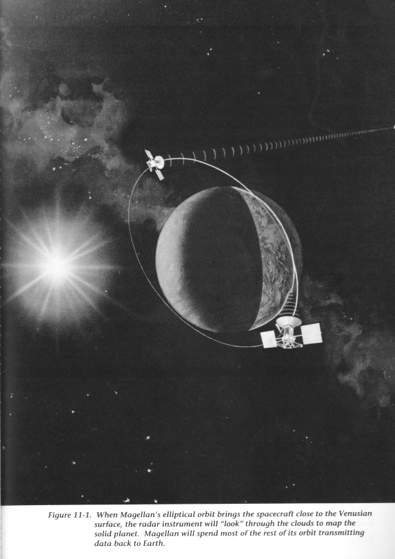
A total of 1,852 data-collection and playback passes (see Figure 11-1) will occur during the 243-day mapping cycle.
Each mapping pass will image a swath of the planet about 25 kilometers (16 miles) wide by about 16,000 kilometers (10,000 miles) long. Since the spacecraft's orbit remains essentially fixed in inertial space, the slow rotation of Venus continually brings new areas into view under the spacecraft. Swath overlap will vary, but averages around 5 kilometers (3 miles). The 243-day mapping cycle will cover a full 360 degrees of Venus longitude. Nearly 90 percent of the surface of Venus can be mapped during the mapping cycle, if all goes well; the rest can be mapped later if there is an extended mission that provides additional mapping cycles.
Because of the orbit inclination, the HGA must point to the left (with respect to the spacecraft's direction of motion) as it crosses over the north pole. Thus the mapping cycle is performed with the spacecraft in a left-looking configuration.
Because of this orientation, the south pole cannot be mapped until and unless the Project is funded for additional 243-day mapping cycles, even if there were enough data-playback time in each orbit to map a full 180 degrees in latitude (which there is not). To map the south pole, the spacecraft will have to be rotated 180 degrees and operated in a right-looking configuration.
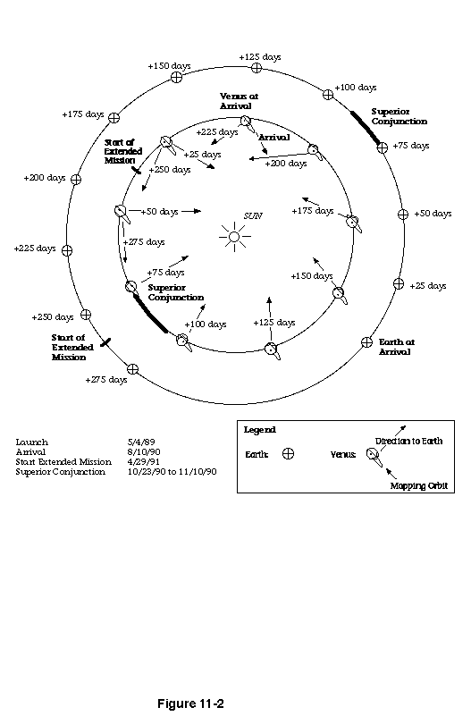
Figure 11-2 shows the geometry of the orbit, Venus, the Sun, and Earth every 25 days from VOI through the 243-day mapping cycle. The location of superior conjunction is also shown in Figure 11-2 as the bold line following the point of VOI +75 days.
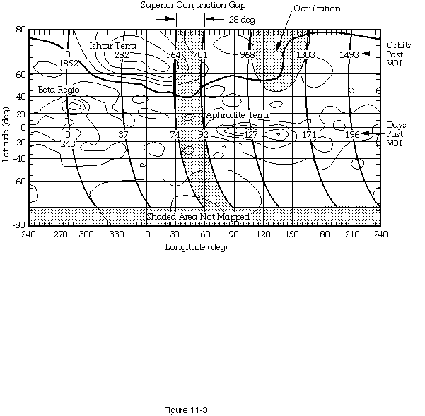
Several of the major geologic regions in Venus' northern hemisphere are shown in Figure 11-3. The slow, retrograde rotation of the planet can be seen as the major features (Beta Regio, Ishtar Terra, and Aphrodite Terra) move as a function of days past VOI.
As mentioned in Chapter 9, the 243-day mapping cycle can be divided into several distinct phases during which spacecraft operations are conducted in slightly different ways. These phases are driven by geometry considerations involving the positions of the Sun, Venus, Earth, and the spacecraft's mapping orbit.
The simplest geometry occurs when there is a clear line of sight between the spacecraft and a DSN receiving station during data playback. The mapping operations conducted in this phase are referred to as "nominal," or "nonocculted." The plans for nominal mapping form the baseline from which alterations will be made to meet the special geometric needs of possible extended mission cycles.
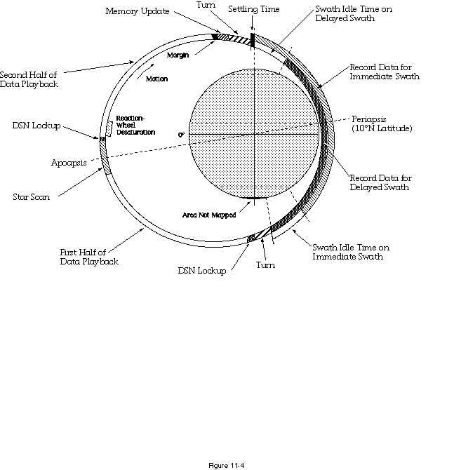
In nominal mapping, the 3.15-hour orbit period is divided as shown in Figure 11-4. An "alternating swath" strategy is used to maximize coverage of the planet. Although Venus rotates the same number of degrees at all latitudes during each orbit, the number of square miles of new terrain under the spacecraft is much greater near the equator than near the poles. This makes it possible to map the high latitudes on every other orbit and still obtain a good margin of data overlap between swaths. The lower latitudes, however, need to be mapped every orbit to avoid holes in the final Magellan Venus map. The alternating-swath mapping strategy thus reduces redundant data collection in the northern polar region and allows collection of data farther south than would otherwise be possible.
Using this strategy, the spacecraft alternates between mapping from the north pole down to 56.9 degrees S latitude on one orbit (an "immediate" swath), to mapping from 66.9 degrees N latitude down to 74.2 degrees S latitude on the next orbit (a "delayed" swath). Mapping orbits are thus either "immediate" or "delayed."
Each record (data-acquisition) period, whether for immediate or delayed swaths, is 37.2 minutes long and fills the onboard tape recorders (called the Data Management Subsystem [DMS]). The tape recorders must be emptied every orbit because they will be refilled with data from the next orbit.
Figure 11-4 also shows the two playback periods that occur during every orbit. The playback rate is 268.8 kilobits per second, which is only one-third the record rate of the radar data. For this reason, the total playback period is three times that of the record period and takes up the bulk of time during each orbit. The playback period is divided into two parts to allow time for a star scan to maintain spacecraft pointing accuracy.
Table 11-1 lists the major mapping events and their time allocations. If the orbit period achieved at VOI is less than 3.15 hours (189 minutes), but not short enough to require an OTM, the time allotments for mapping events will be adjusted. Maximum mapping coverage is the goal and serves as the guideline for any timing adjustments.
Table 11-1.  Mapping Orbit Time Allocations
-------------------------------------------
Event             Duration, minutes
-------------------------------------------
Turn to mapping          5.7
Setting time             0.5
Record mapping          37.2
Swath idle time          7.5
Turn to play back        5.3
DSN lockup               2.5
First playback          56.6
Star scan               14.0
Second playback         57.2
Memory update            2.0
Margin                   0.5
-------------------------------------------
Total                  189.0
-------------------------------------------
During that phase of the prime mission when the Sun is very nearly between the Earth and Venus (approximately 18 days centered on November 2, 1990), the superior conjunction mapping plan will be used. Concerns that constrain planning for superior conjunction are twofold.
The mission plan for the superior conjunction phase, therefore, calls for us to stop mapping altogether from October 31 through November 5, 1990. Mapping operations will continue until October 31 only if the Sun is "quiet." During this period, we will try to get engineering telemetry from the spacecraft for one work shift per day.
We will study the quality of the telemetry throughout the conjunction period and will resume mapping as soon as it is safe to do so. If nature smiles on us, no more than 7 to 10 days of mapping data will be lost during this period.
The occulted mapping phase (December 16, 1990, to January 26, 1991) will find Venus between the spacecraft and Earth for part of the playback portion of the orbit. During this phase, the record duration will be reduced and the mapping parts of the orbit shifted to reduce the amount of playback time required to the precise amount geometrically available. Magellan science investigators expressed a preference for obtaining coverage at the southern extreme of the mapping pass during this phase, since this area will be "new" terrain. Therefore, the start of the 44-minute mapping pass will be delayed during this phase, with the amount of delay determined by the maximum length of the occultation during the period covered by the stored sequence on the spacecraft. This will put a "hole" in the Magellan Venus map in the northern latitudes, also shown in Figure 11-3.
The Magellan prime mission is that period between the end of IOC and April 29, 1991, approximately the time it takes Venus to rotate once beneath the spacecraft's orbit. If we are able to start collecting map-quality data 19 days after VOI (i.e., only if things go well in IOC and no OTM is needed), we will be able to "close the map" by the end of the prime mission. If an OTM is needed, or if map-quality data are not collected until sometime after mapping operations have begun (nominally September 1), several days of mapping past the nominal end of the prime mission will be required.
Because spaceflight operations rarely proceed without a hitch, several alternate mapping strategies have been developed. In general, contingency planning is best accomplished in cool, collected moments, not in the heat of an emergency. With that in mind, we have planned ahead for a dozen or so categories of problems that could change the way mapping data are collected from the time of the failure forward (see Table 11-2).
Since the spacecraft is built to be single-fault tolerant, most single failures allow the automatic substitution of a backup component for the failed one, and operations can recover the original mapping strategy with very little lost time or data. More complex failures, however, require preplanning to avoid excessive lost time in replanning at the time of the emergency.
Even so, there is no guarantee that quick contingency planning will not be required at some point in the mission -- nature often finds a way to break those things we are least prepared to have broken. Development of a number of plans ahead of time, however, has always proven to shorten the time required to replan strategy following an actual failure, even if the failure is one for which no plans have been made.
An extended mission to recover data missed during the first 243-day mapping phase (Cycle 1) and to conduct the high-resolution gravity experiment is a vital part of achieving all of the science objectives of the Magellan mission.
Preliminary preparation for the first extended mission cycle (Cycle 2) was conducted during the cruise period. The final planning for Cycle 2 and the preliminary work for subsequent cycles will be addressed during Cycle 1 (prime mission) operations.
Extended mission science objectives were developed in collaboration with the Magellan science investigators. Those objectives are divided among several mission cycles, as follows.
Cycle 2 primarily involves radar mapping. Its main objective is to fill in all large coverage gaps left from Cycle 1. These gaps will be of three kinds: those that were geometrically impossible to obtain during Cycle 1 (i.e., those during superior conjunction and apoapsis occultation, and those of the south pole), those that may have occurred because of DSN coverage losses from any delay in "start up" at the end of IOC and the beginning of mapping, or those from any problems encountered during Cycle 1 that resulted in data loss.
The focus on radar data in Cycle 2 is due partly to the importance of obtaining a complete map of Venus to support geological interpretation of the planet and also to the geometric impossibility of proceeding to the high-resolution gravity experiment until late in Cycle 2 (the last 32 days). It may well be that the gravity experiment will begin in the last month of Cycle 2.
The high-resolution gravity experiment requires pointing the spacecraft's HGA at Earth during periapsis. When Venus is between the spacecraft and Earth during this part of the orbit, the gravity experiment cannot be performed. Only during the times when periapsis is not occulted can this part of Magellan's mission objectives be met.
Conducting the gravity experiment is the prime objective in Cycles 3 and 4; the fill-in of any remaining SAR coverage gaps will take place on a time-available basis.
![]() Chapter 12 - Getting the Job Done
Chapter 12 - Getting the Job Done
![]() The Magellan's Venus Explorer Guide
The Magellan's Venus Explorer Guide
