
Magellan Mission at a Glance

Mission Summary
The Magellan spacecraft, named after the sixteenth-century Portuguese
explorer whose expedition first circumnavigated the Earth, was launched May 4,
1989, and arrived at Venus on August 10, 1990. Magellan's solid rocket motor
placed it into a near-polar elliptical orbit around the planet. During the
first 8-month mapping cycle around Venus, Magellan collected radar images of
84 percent of the planet's surface, with resolution 10 times better than that
of the earlier Soviet Venera 15 and 16 missions. Altimetry and radiometry
data also measured the surface topography and electrical characteristics.
During the extended mission, two further mapping cycles from May 15, 1991 to
September 14, 1992 brought mapping coverage to 98% of the planet, with a
resolution of approximately 100m.
Precision radio tracking of the spacecraft will measure Venus' gravitational
field to show the planet's internal mass distribution and the forces which
have created the surface features. Magellan's data will permit the first
global geological understanding of Venus, the planet most like Earth in our
solar system.

A global view of Venus made from a mosaic of radar imagery from the
Magellan spacecraft. This computer-generated globe shows the planet from
above the equator at 180 degrees longitude. It shows the coverage of Venus
during Magellan's highly successful first mapping cycle, completed in 1991.
Magellan continues to gather data that will influence our understanding of
terrestrial planets for years to come.
Venus
Distance from Sun: 1.1 x 10^8 km
Orbit Period: 225 Earth days
Radius: 6051 km
Rotational Period (sidereal): 243 Earth days
Average Density: 5.24 g/cm3
Surface Gravity: 0.907 times that of Earth (8.87 m/s2)
Surface Temperature: 850 F (730 K)
Surface Atmospheric Pressure: 90 times that of Earth (90 +- 2 bar)
Atmospheric Composition:
    Carbon dioxide (96%); nitrogen (3+%); trace
    amounts of sulfur dioxide, water vapor, carbon
    monoxide, argon, helium, neon, hydrogen chloride,
    hydrogen fluoride
Major Mission Characteristics
Interplanetary Cruise: May 4, 1989, to August 10, 1990
First Mapping Cycle: September 15, 1990 to May 15, 1991
Orbit Period: 3.25 hours
Orbit Inclination: 86 degrees
Radar Mapping Per Orbit: 37.2 minutes
Planetary Radar Mapping Coverage: 98%
Planetary Gravity Data Coverage: 95%
Extended Mission: September 15, 1991
Cycle 2: Image the south pole region and gaps from Cycle 1
Cycle 3: Fill remaining gaps and collect stereo imagery
Cycle 4: Measure Venus' gravitational field
Cycle 5: Aerobraking to circular orbit and global gravity measurements
Cycle 6: Collect high-resolution gravity data an conduct radio science experiments
Windmill Experiment: Observe behavior of molecules in upper atsmosphere.
Termination Experiment: October 11, 1994
Mission Objectives
- Obtain near-global radar images of Venus' surface, with resolution equivalent to optical imaging of 1 km per line pair.
- Obtain a near-global topographic map with 50km spatial and 100m vertical resolution.
- Obtain near-global gravity field data with 700km resolution and 2-3 milligals accuracy.
- Develop an understanding of the geological structure of the planet, including its density distribution and dynamics.
Magellan Team
NASA/Solar System Exploration Division
- Elizabeth E. Beyer, Program Manager
- Joseph M. Boyce, Program Scientist
- David J. Okerson, Program Engineer
JPL
- Douglas G. Griffith, Project Manager
- James F. Scott, Former Project Manager
- Anthony J. Spear, Former Project Manager
- John Gerpheide, Former Project Manager
- R. Stephen Saunders, Project Scientist
Principal Investigators
- Radar: Gordon Pettengill (MIT)
- Gravity: William Sjogren (JPL), Georges Balmino (France)
System Contractors
- Spacecraft: Martin Marietta/Denver, F. McKinney, Manager
- Radar: Hughes Aircraft, B. Dagarin, Manager
Key Spacecraft Characteristics
- Single radar instrument operates simultaneously (by interleaving) in Synthetic Aperture Radar (SAR), altimeter, and radiometer modes.
- High Gain Antenna (3.7m diameter) is used as both the radar and telecommunications antenna.
- X-band downlink data rate of 268.8 or 115 kbps.
- Coherent X- and S-band radio subsystem used for gravity field measurement by precision tracking of the spacecraft's orbit.
- Spacecraft on-orbit dry mass of 1035 kg.
- Monopropellant hydrazine thruster system (0.9 to 445N thrust).
- Powered by solar panels with rechargeable batteries.
- Three orthogonal electrically powered reaction wheels used for spacecraft pointing control.
Key Radar Characteristics
- Synthetic Aperture Radar (SAR)
- Frequency: 2.385 GHz
- Peak Power: 325 W
- Pulse Length: 26.5 microsec
- PRF: 4400-5800 Hz
- Swath Width: 25 km (variable)
- Data Acquisition Rate: 806 kbps
- Downlink Quantization: 2 bits
- Operates in SAR, altimeter, and radiometer modes
- SAR Resolution: 150m range/150m azimuth
- Altimeter Resolution: 30m
- Radiometer Accuracy: 2 degree C
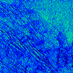
Sample Magellan SAR data in false color showing surface of Venus
Key Scientific Results
Study of the Magellan high-resolution global images is providing evidence to
understand the role of impacts, volcanism, and tectonism in the formation of
Venusian surface structures.
The surface of Venus is mostly covered by volcanic materials. Volcanic surface
features, such as vast lava plains, fields of small lava domes, and large shield
volcanoes are common.
There are few impact craters on Venus, suggesting that the surface is, in
general, geologically young - less than 800 million years old.
The presence of lava channels over 6,000 kilometers long suggests river-like
flows of extremely low-viscosity lava that probably erupted at a high rate.
Large pancake-shaped volcanic domes suggest the presence of a type of lava
produced by extensive evolution of crustal rocks.
The typical signs of terrestrial plate tectonics - continental drift and basin
floor spreading - are not in evidence on Venus. The planet's tectonics is
dominated by a system of global rift zones and numerous broad, low domical
structures called coronae, produced by the upwelling and subsidence of magma
from the mantle.
Although Venus has a dense atmosphere, the surface reveals no evidence of
substantial wind erosion, and only evidence of limited wind transport of dust
and sand. This contrasts with Mars, where there is a thin atmosphere, but
substantial evidence of wind erosion and transport of dust and sand.
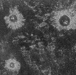
Sample Magellan SAR data showing surface features
For More Information on Data
Photographic images, digital data
CD-ROMs
and display software, and videotapes showing computer-generated flights over
Venus are available to researchers, educators, and the public through the
National Space Science Data Center, Goddard Space Flight Center, Mail Code 633, Greenbelt, MD 20771,
(301) 286-6695, Fax: (301) 286-1771.
Detailed catalog information is available to researchers funded by NASA's
Solar System Exploration Division through the Planetary Data System,
Geosciences Node, Earth and Planetary Remote Sensing Laboratory, Washington
University St. Louis, MO 63130-4899, (314) 935-5493, Fax: (314) 935-7361,
e-mail: request@nssdca.gsfc.nasa.gov.
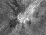
Sample Magellan SAR data showing surface features
Photographic imagery, CD-ROMs, and videotapes are available for browsing at
NASA's 15 Regional Planetary Image Facilities.
Teachers can obtain information about Magellan, including copies of the
videotapes, through NASA's Teacher Resource Centers.
 Magellan Home Page

